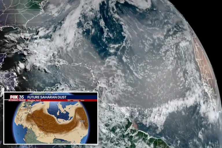
A vast plume of dust originating from the Sahara Desert blanketed much of the Caribbean on Monday, marking the most significant Saharan dust event of 2025 and prompting health advisories as it moves toward the southeastern United States.
The massive cloud stretched over 2,000 miles, spanning from Barbados to Jamaica and extending roughly 750 miles south from the Turks and Caicos Islands to Trinidad and Tobago. Known as the Saharan Air Layer, this dry, dust-laden air mass forms over the Sahara Desert and travels westward across the Atlantic between spring and fall.
“It’s very impressive,” said Alex DaSilva, lead hurricane expert at AccuWeather. “This is the strongest plume we’ve seen so far this year.”
In affected areas, the skies turned hazy, sunlight was muted, and air quality deteriorated significantly. Meteorologists and health officials across the region warned residents—particularly those with asthma, allergies, or other respiratory conditions—to stay indoors or wear protective masks when outside.
In Puerto Rico, the dust concentration measured 0.55 on the aerosol optical depth scale, the highest reading recorded this year, according to Yidiana Zayas of the U.S. National Weather Service in San Juan. The scale measures how much sunlight is blocked by airborne particles, with higher values indicating denser concentrations.
The plume is expected to continue drifting northwest and is forecast to reach the U.S. Gulf Coast—including Florida, Louisiana, Alabama, and Mississippi—by late this week into the weekend. While Saharan dust typically thins out as it crosses into North America, forecasters caution that the density and extent of this plume may still degrade air quality in parts of the southern U.S.
“These plumes often dissipate over distance, but this one has an unusually high concentration,” said DaSilva. “In the eastern Caribbean, it’s dense enough to noticeably dim the sun.”
Saharan dust events typically occur between April and October and are most intense in June and July. While they can reduce visibility and affect air quality, they also have a silver lining: the dry, stable air can suppress tropical storm formation during the early months of the Atlantic hurricane season.
A similar event in June 2020 made headlines worldwide when a record-breaking dust cloud engulfed the Caribbean. Dubbed the “Godzilla dust cloud,” it was the most intense Saharan dust outbreak observed in more than 50 years.