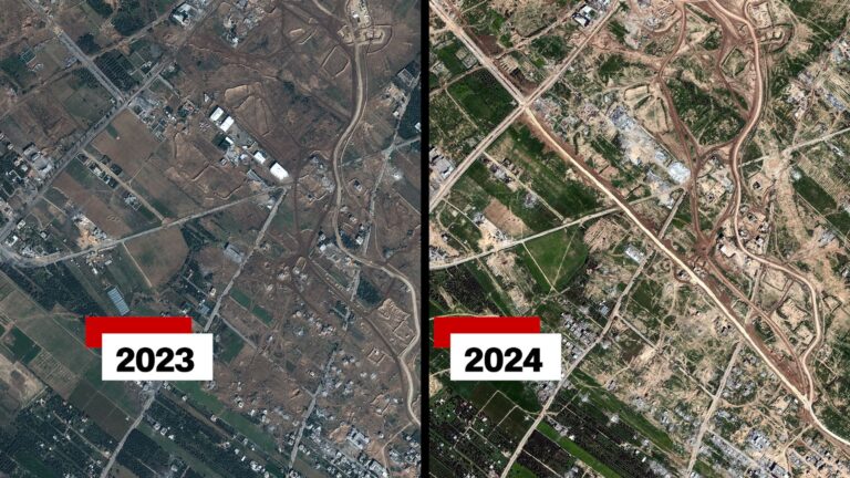
Verified Satellite images shows that the Israel Defense Forces (IDF) have completed the construction of a new road spanning northern Gaza from east to west.
The IDF stated that the purpose of the road is to establish an “operational foothold” and facilitate the movement of troops and equipment in the region.
However, concerns have been raised by experts that the road could serve as a barrier, potentially impeding Palestinians from returning to their homes in the northern area of Gaza. Some analysts also speculate that it may be part of Israel’s strategy to prolong its presence in Gaza even after the current hostilities cease.
Prime Minister Benjamin Netanyahu previously outlined a post-war vision in February, proposing that Israel maintain security control in Gaza indefinitely.
Israel has faced previous international warnings against permanently displacing Palestinians or reducing the size of Gaza.
The newly constructed road in question traverses north Gaza, positioned above central and southern areas. It originates at Gaza’s border fence with Israel near the Nahal Oz kibbutz and concludes its route near the coastline.
Notably, the road intersects with the Salah al-Din and al-Rashid roads, which are the primary thoroughfares in the territory.
Unlike the existing network of roads connecting the east and west, the recently established IDF route is the sole uninterrupted road cutting across Gaza.
Satellite analysis conducted by the BBC indicates that the IDF has constructed over 5km (3 miles) of new road segments, linking previously unconnected roadways.
The eastern section of the road, situated near the Israeli border in Gaza, was initially constructed between late October and early November. However, the majority of the additional segments were completed during February and early March.
Notably, the newly established route boasts a wider design compared to a standard road in Gaza, with the exception of Salah al-Din.
Upon analyzing satellite imagery, it becomes apparent that structures along the route, potentially warehouses, were dismantled from the end of December until late January. This includes the demolition of a multi-story building.
It is noteworthy that the road spans an area that previously featured fewer buildings and lower population density compared to other parts of Gaza.
Additionally, it is positioned beneath an improvised and meandering path that the IDF had utilized for east-to-west movement.
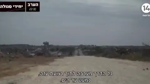
An Israeli television channel highlighted the route in February, disclosing its codename as “Highway 749”. A journalist from Channel 14 journeyed along segments of the route in the company of the Israeli military.
In the footage, construction vehicles and excavators were observed engaged in groundwork for the development of fresh sections along the route.
The IDF’s statement did not delve into this level of specificity. “As part of the ground operation, the IDF uses an operational route of passage,” it mentioned.
Retired Brig Gen Jacob Nagel, former head of Israel’s National Security Council and a former security adviser to Mr Netanyahu, said that the primary purpose of the new route was to facilitate rapid access for security forces in addressing emerging threats.
“It will help Israel go in and out… because Israel is going to have total defence, security and responsibility for Gaza,” .
He characterized it as “a road that divides the northern part from the southern part.”
“We don’t want to wait until a threat is emerging,” he emphasized.
Maj Gen Yaakov Amidror, formerly of the IDF, shared a comparable perspective. He asserted that the primary objective of the new road was to “facilitate logistical and military control in the region.”
Justin Crump, a former British Army officer and the head of Sibylline, a risk intelligence company, emphasized the importance of the new route.
“It certainly appears to be a component of a broader, long-term strategy aimed at establishing some level of security intervention and control in the Gaza Strip,” stated Mr. Crump.
“This zone acts as a barrier, isolating Gaza City from the southern part of the strip, creating an efficient control line for monitoring or restricting movement, and offers relatively unobstructed fields of view.”
Khaled Elgindy, a senior fellow at the Middle East Institute in the United States, shares the perspective that the road signifies a long-term initiative.
“It seems that the Israeli military intends to maintain a presence in Gaza for an extended period,” he said further.
“By dividing Gaza into two, Israel gains control not only over the ingress and egress of the territory but also regulates internal movement within Gaza,” explained the analyst.
“This could potentially involve preventing the 1.5 million displaced Palestinians in the south from returning to their homes in the north.”